EPI’s Applied Geophysical Solutions team offer a suite of survey design, processing, and quality control services; covering onshore, offshore and transition zone seismic survey data acquisition and processing.
Survey Design
EPI specialise in robust survey design, perfectly suited to the specific needs of any project.
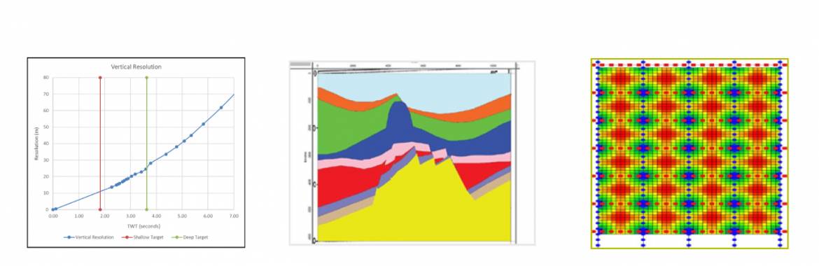
Using subsurface de-risking methodology incorporating both proprietary techniques and fundamental methods developed by Vermeer, Cordsen and Galbraith to produce survey designs and parameters that don’t just focus on the imaging but provide a robust solution. EPI undertakes a full suite of modelling, utilising the following procedures into our design flow:
- 3D Layout and Geometry Diagnostics (Schlumberger OMNI software).
- 3D Geological Modelling and Illumination Study (OMNI Workshop).
- 2D Elastic Wave Equation Modelling (OMNI Workshop).
- Wedge Modelling (Hampson-Russell).
- Footprint Analysis (OMNI Workshop).
- Optimum Shooting Plan and Cost Analysis (SurvOpt Acquisition Planning Tool).
Marine Seismic Survey First Line QC Service
EPI recommend that all seismic and navigation data are subjected to an independent analysis and verification prior to commencement of all marine seismic operations, at specific stages (start of survey, re-configuration) and prior to deliverables being archived.
An integrated deep-dive into data integrity, formats and quality is undertaken to ensure that data is being recorded and delivered according to industry standards.
To this end EPI offer the following services:
1. Navigation First Line QC
- Navigation
Check P2 and P1 data formats, analysis of positioning networks, verify headers, check geodetic parameters, process raw data and compare to P1.
- Spread
Examine geometry and stability of spread, examine contract tolerance adherence of spread, & deviation of various nodes from preplot.
- Source
Verify shot flags/fired status; examine depths, pressures, volumes and timing delays; examine separations, laybacks and tow skew & examine seismic RMS attributes for source balance.
- Streamers
Examine separations at every offset; examine depth at every offset; examine bird wing data for angles and steering forces; examine RMS noise attributes at each receiver.
2. Seismic First Line QC
- Read/Verify nav merged SEG-Y
- Read/Verify raw SEG-D
- Check seismic data can be read and reformatted and the data looks as expected.
- Check all SEG-Y header mappings.
- For every header the following is also checked where appropriate: Min/max values, Min/Max increments, Number of zero samples, Check for NaNs for floating point numbers, Maximum number of consecutive traces with the same value. Positional headers are cross checked against values read from the navigation data.
- Check the EBCDIC header for SEG-Y standard conformance and completeness/accuracy of contents.
EPI provides a secure file transfer facility (SFTP) via dedicated server where a client or contractor can upload data for verification, alternatively we can download data from a client’s server.
Turnaround is typically 24 hours from receipt of sample data and a comprehensive report is provided highlighting any areas of concern. All analysis is performed by highly experienced processors using state of the art software.
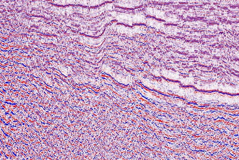
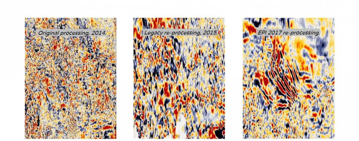
Seismic Data Processing
EPI’s data processing team take pride in their ability to reprocess difficult datasets, offering advice, investigations and reports on many aspects of image related services.
- Custom-built testing and sequence development, along with small-volume production processing – (using Shearwater Reveal & GLOBE Claritas software) – providing a truly individual processing service.
- For larger surveys, feasibility testing can be run in-house to establish optimal parameters prior to passing the full dataset to a partner company to run the main production processing. EPI’s partners also use Reveal, ensuring a quick and seamless transition from testing to production.
- All EPI geophysicists have a minimum of 20 years’ experience, handling the imaging from start to finish.
- Pre-processing includes advanced statics, denoise and de-multiple techniques such as 3DSRME and SWME.
- Time and Depth imaging solutions include Kirchhoff, Beam, Common Reflection Angle and Reverse Time Migration.
Seismic Processing QC
Seismic processing QC provides external supervision for processing projects to ensure that clients are provided with the highest possible products within their budget and timeframe.
EPI have a group of highly experienced processing consultants specialising in time and depth processing in Marine, Land & Transition Zone environments. All our consultants have over 20 years of industry experience in geographical areas spanning the globe. They are also conversant with technologies at most of the larger processing houses.
Key aspects of the role are as follows:
- Understanding the client’s key objectives and main target areas, ensuring these are understood and observed by the processing team throughout the project.
- Ensuring that the processing contractor has all the necessary data and information.
- Developing an appropriate testing sequence and ensuring that the project schedule is achievable.
- Ensuring Quality Control standards and schedules are met throughout the project and suggesting remedial action where necessary.
- Review of all testing and parameter selection.
- Meeting face to face with the processing contractor on a regular basis and providing meeting reports to clients.
- Awareness of the processing schedule and cost, making the client aware of any possible delays or additional charges, in advance, such that mitigation procedures may be put in place if necessary.
- Inspect and assure all processing final products are in good condition, including the Final Processing Report.
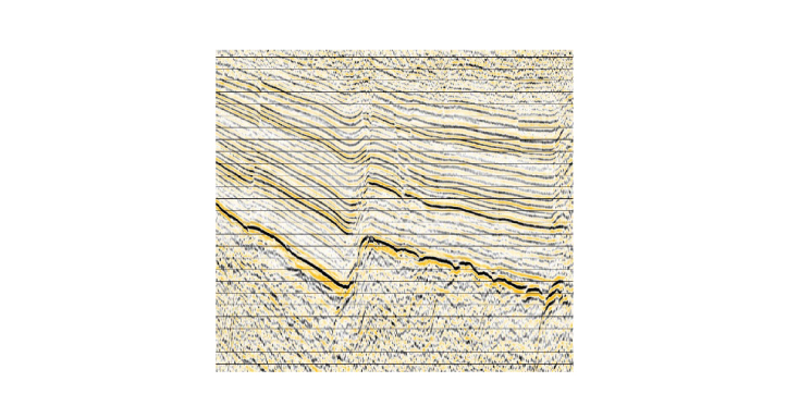
In addition to a review of data at the Contractors office, or via PowerPoint, EPI have a fully licensed Shearwater Reveal processing system on which SEGY format data, despatched by the Contractor, can be loaded. This allows the running of confirmatory parameter testing, interactive QC procedures, and checking of sample final deliverables etc. EPI also have Petrel and Kingdom interpretation software available to assist in visualisation of large 2D and 3D volumes.
Why use the EPI Group?
- We ensure the subsurface response to the geophysical methodology supports the imaging requirements.
- Our solutions have a proper and full integration between:
- Asset required derisking method. e.g. seismic attribute/AVO sensitivities.
- The envisaged data processing and imaging sequences required.
- Acquisition parameters.
- Operational Feasibility.
- We assure our solutions are not only geophysically correct, but offer an excellent level of interpretability. We work hand in hand with our Geoscience Division to make sure our data output can be utilised and the data attributes can be captured to further the derisking strategy.
- We make sure the data will not only delineate targets, but also afford appropriate derisking of the anticipated drilling and development operations.
Tendering and Contract Development
- Our services include market evaluation and expressions of interest (EOIs).
- We provide full tendering, along with local & national law compliance, following best industry practises.
- We supply a suite of documentation which is fully flexible to ensure any requirements are covered.